


MapCircle
MapCircle介绍
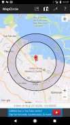
MapCircle is a simple app that allows you to visualize distances by displaying a map with an overlaid circle or donut of a specified radius.
The circle view is useful when you want to see everything that's less than some specified distance from some location.
The donut view is useful when you know that something is "a mile away" (or some other distance), but aren't sure exactly WHERE it is & want to try and guess its likely location. The donut itself represents the region of uncertainty and margin of error.
Features:
* Distance in Miles and Kilometers
* Easily toggle between regular and hybrid map views (hybrid is aerial/satellite image with overlaid map)
* Two visualization types: circle and donut
MapCircle是一个简单的应用程序,允许用户通过显示与指定半径的重叠圆圈或圆环的地图可视化的距离。
当你想看到的一切使用小于从某个位置某种指定的距离,圆的观点是有用的。
当你知道什么是“一英里”(或其他一些距离),但不知道它的确切位置和要尝试和猜测它可能位置的甜甜圈的观点是有用的。甜甜圈本身就代表着不确定性和误差范围的区域。
特征:
*距离miles和公里
*轻松定期和混合地图视图之间切换(混合是空中与地图重叠/卫星图像)
*两个图表类型:圆和圆环
MapCircle - 版本1.05
(20-01-2020)MapCircle - APK信息
APK版本: 1.05程序包: software.pantherkitty.mapcircleMapCircle的最新版本


同类应用


